NOTICES AND UPDATES
garden city realty TROPICAL STORM imelda updates
If you are currently staying in a Garden City Realty vacation rental property or have an upcoming reservation, please check the email address associated with the reservation for updates from our Guest Services department.
TO OUR GUESTS
- Please monitor your email for the latest storm updates.
SURFSIDE BEACH LIVE BEACH WEBCAM
2025 STORM & Hurricane UPDATES
september 26, 2025
Weather Authority Hurricane Center - WPDE ABC 15 News
Ed Piotrowski WPDE - Tropical Storm Imelda Update - FRIDAY 12 PM 9.26.2025
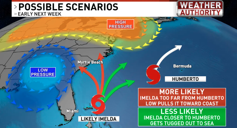
Future Imelda is still poses a significant threat to the Carolinas, though the extent of the threat is still uncertain given the complex steering currents ahead.
FUTURE IMELDA INTENSITY | The tropical wave expected to develop into Imelda is near the eastern tip of Cuba right now and will move into the southeast Bahamas tonight. With very warm waters and light wind shear, conditions favor organization into a tropical storm by late Saturday. Additional strengthening is likely, and a low-end hurricane is possible Sunday or Monday. That said, models suggest that intrusions of dry air and eventually increasing wind shear could keep the system lopsided, limiting the potential for rapid intensification. At this point, a strong tropical storm or Category 1 hurricane looks most likely.
TIMING | Potential impacts could begin as early as Monday afternoon and last through Tuesday. This weekend is a good time to review your hurricane plan.
POTENTIAL IMPACTS | It’s still too early to pin down exact details, but if Imelda comes ashore, here’s what we may expect:
- RAIN | Moisture drawn north from Imelda will interact with a stalled front, producing scattered downpours through the weekend with 1–3" possible. Widespread heavy rain is likely Monday and Tuesday, with localized totals of 10”+ possible along and just north of the track. Remember, the track could be well north or south of us, reducing impacts, or right over us with major impacts. Flooding will be a concern, even as the rain helps relieve drought conditions.
- WIND | Most guidance supports a strong tropical storm or low-end hurricane. The strongest winds will occur along and north of the center, capable of producing damage.
- TORNADOES | The highest risk would be in the front-right quadrant of the storm (northeast of the center).
- STORM SURGE | Coastal areas near and north of landfall face the greatest surge risk, with the storm’s perpendicular approach enhancing flooding potential. Areas south of the center could experience a “blow-out tide” as winds push water offshore.
SOUTH CAROLINA STORM UPDATES
Use best practices to prepare for the tropical season. Stay tuned here for updates to keep you and your family safe during a hurricane emergency.
Quick Links
Contact
Open 9:00 a.m. - 5:30 p.m. Monday through Saturday
Copyright © 2026 Garden City Realty. All Rights Reserved. Web Design by InterCoastal Net Designs